SPOILER ALERT: There are significant reveals of book information in order to support the design of these maps. Please do not continue if you do not wish to have this information revealed to you.
General Map Information
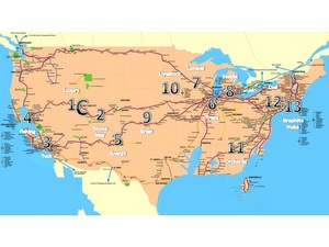
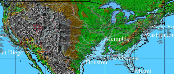
There are two maps in this article. The first was a rough draft for quickly placing the general location of the districts during research. The second map is more detailed and provides boundaries for each of the districts. The map is large and the boundary lines in it are small so you may have to zoom in to see them.
Analysis - General
The location of the districts is based on three things:
1. Terrain analysis. Both maps assume a 100m rise in ocean/sea levels. They are both overlayed with a map of current Amtrak train routes. The detailed map includes elevation terrain features and major waterways which would provide a natural boundary to a district.
2. Historical data of commerce within the United States.
3. Information from the books. Citations from the books will follow a (b:c) format where b=book and c=chapter.
District Placement
Capitol - Ringed by 13 districts (1:1), Rockies (1:3), accessible through tunnels only from the east districts (1:4), its own nuke arsenal on its outskirts (3:2, 3:14). It can be interpreted based on this data that there are western districts. Salt Lake City is a reasonable location as it seems to fit nicely with the book details and the fact that a major train route goes through it.
District 1 - Luxury Items (1:5), machine that turns graphite into diamonds (1:6), well-fed, Careers (1:7), lap-dogs (1:12). Luxury items can be made most anywhere and the district need not be big. Situating it right to the west of the Capitol would allow for it to receive the protection of the Capitol and ensure speedy delivery of its products. The fact that it is a lap-dog district would suggest that it is one of the Western Districts that enjoy a close relationship with the Capitol.
District 2 - Stone Quarries, Weapons Manufacture, Peacekeeper Recruitment and Training (3:6), well-fed, Careers (1:7), lap-dogs (1:12). A large district comprised of many vilages spread across the mountains (3:14). "The Nut" fortress that is the major Capitol military stronghold (3:14). District 2 seems to be the gatekeeper to the Capitol and therefore should surround it at least from the east.
District 3 - Factories: televisions, automobiles, explosives (1:16), electronic gadgets (2:12). First to fall under rebel control along with 11 during second uprising. Keeping with the lower numbered districts being to the west and the heavy electronics nature of the district the southern California area seemed a good choice.
District 4 - Seafood (2:12), fishing (2:13), well-fed, Careers (1:7), lap-dogs (1:12), Bread with seaweed (1:7), second to revolt (2:12). In an interview with Suzanne Collins, she states that District 4 is on the Pacific. This in conjunction with the flooding of northern California make it an ideal location. This continues the trend for low numbered, Capitol-friendly districts to be out west.
District 5 - Power Generation (official movie promotion webpage), nuclear, solar, electric (from Tribute Guide). The Capitol would most likely have its own limited power supply to prevent its fall due to a loss of District 5. Still it would want close protection from District 2. With this in mind District 5 would most likely provide power for the other Districts, the telephone and television transmission systems, and probably more importantly, the games arenas based on their heavy terraforming and force field usage. Since the old arenas are tourist attractions for Capitol citizens it would seem reasonable that they would be close and built on terrain of little value for anything else, namely desert. It reliance on solar and wind and nuclear would make Texas, New Mexico, and Oklahoma an ideal location.
District 6 - Transportation, namely hovercraft and trains (Tribute Guide). Based on the hub of train travel which is the primary means of inter-district travel. The former Chicago region is the modern day train hub and considering that train routes are a major engineering effort it would seem to make sense to keep them near about where they were in the past. This could also represent the fuel stop that the train taking Katniss and Peeta to the 74th Hunger Games occurred.
District 7 - Lumber and paper (2:15), broken dam during second revolution (3:9). Upper Michigan and Wisconsin are a lumber region. This district must also lie next to 10 and on the way to the Capitol from District 12, with an arrival during night time (1:4). No other historical lumber region would fit.
District 8 - Textiles (2:6), first to revolt in second revolution (2:6). The path between 6 and 8 must be within reasonable distance from 12 as the refugees from 8 that Katniss met fled on foot from a train fuel stop between the two (2:10). This could be the same fuel stop the train that took Katniss and Peeta to the 74th Hunger Games.
District 9 - Grain (official movie promotion page). The historical breadbasket of North America is the logical place for this district.
District 10 - Livestock (2:15). Dalton travelled from 10 to 13 years before the story begins (3:1). Minnesota and Iowa is historically significant livestock region. It is next to 7 making Katniss's statement about seeing distant lights and wondering if they are from 7 or 10 make sense.
District 11 - Agriculture, Orchards (1:15), along with District 3, it was the first to be under rebel control in the second revolution (3:9). According to an interview with Suzanne Collins, this District was to be around Atlanta.
District 12 - Mining, Coal (1:1), located in Appalachia (1:3), portion nicknamed "The Seam" (1:1), entire district surrounded by a 20-feet high electrical fence (1:1), less than one day travel by high-speed (250mph) train to Capitol (1:3), Population: 8000 (1:1), end of the line unless you count District 13 (1:6). Within a week's walk from District 13 or 45 minutes by hovercraft (3:2). The Northern Anthracite Field of NE Pennsylvania is the most logical location. It is along a train route, close to NJ where
District 13 should be, small enough to be surrounded by an electric fence, and anthracite coal has more energy than the bituminous coal of other regions, therefore its mining and transport would be more efficient. Based on new information regarding the Raven Rock Mountain Complex in PA and Mt. Weather in VA, brought to my attention by Tracee Orman, I have revised the location of 12 to be the ridgeline just south of Cumberland, MD which has several coal mines in a close area near a rail station.
District 13 - Graphite Mining (1:6), Nuclear Research (2:10), underground (2:10), beyond District 12 (1:6), large population (2:10), but many infertile due to a pox (3:1). Although no know graphite deposits exist in New Jersey it has significant artificial graphite manufacture. It is sufficiently close to the Northern Anthracite Field of NE Pennsylvania and much military-industrial complex infrastructure. Based on new information regarding the Raven Rock Mountain Complex in PA and Mt. Weather in VA, brought to my attention by Tracee Orman, I have revised the location of 13 to be a merging of these complexes.
Other Contributing Factors
These locations are supported further by the book in that besides District 12, which is too small to be of significant value, District 8 and District 11 are the closest to District 13. District 8 revolted first which could have been the result of ease of infiltration by District 13 to sow the seeds of discontent. District 11 along with 3 was the first to be under rebel control, as it is also the furthest from the Capitol. Although the path backtracks a little bit, the path of the Victor Tour going from District 12 to 1 in order, skipping the Victor's District (2:1), would be fairly logical with this layout. District 11 and 12 are furthest from District 5, the power district, which would explain the fact that the fence and other electrical items are rarely with power in 12 and the fact that they use the night vision glasses to pick fruit in District 11 rather than having lighting, suggesting that electricity is scarce there too.


